For what I hope is short lived I have found myself with a bit more free time on my hands this summer, but while I do have that time my husband and I have decided we’re going to try very hard to do some of those things we’ve been saying we want to do. Yesterday we made good on our promise to each other, and set out on our first adventure to downtown Minneapolis and the Mill City Museum and Mill Ruins Park. The Mill City Museum is located on the Mississippi River on the east side of downtown, and tells the story of the history of when this beautiful city of lakes (and a very big river) was the capital of flour milling. From the late 1800’s into the mid 1900’s in the birthplace of General Mills and Pillsbury, the mills on the banks of the Mississippi produced the largest percentage of the worlds flour, and by 1915-16 was producing 20 million dry barrels annually. (Total geek that I am, today we measure flour production in cwts, which is a hundred weight, or 100 lb, and a barrel had about 196 lb of flour. That’s about 3920 million cwts annually. Minnesota’s production in the first quarter of 2017 was 6.86 million cwts, putting us 4th in the nation.)

Mpls milling district from the Mississippi River, approx 1907. The Washburn A Mill is about in the center. The tall spire with the round clock looks like it’s part of it, but it’s actually behind it. Note the original Stone Arch Bridge on the right, and the railroad trestles in front of the mills. Some trestle remains exist in the ruins today. Photo from MN Historical Society
The city was knicknamed “The Mill City” and even had a professional basketball team for a time, the Minneapolis Millers for those of you old enough to remember them. (As a kid, I’d heard of the Millers, but always thought “what an odd name for a team, I wonder why they called them that?” I never thought to ask my parents. Now of course, 30 seconds on the internet and there’s your answer!) One of the things makes the museum and the park so interesting is that the old mill is the site of 2 fires, and the park has a portion of the mill ruins that were excavated.
The first Washburn A Mill, built in 1874, “was leveled by a flour dust explosion that claimed 18 lives. That explosion and the resulting fire destroyed much of the riverfront business area, cutting Minneapolis’ milling capacity in half.
The A Mill was rebuilt by 1880, with state-of-the-art machinery that permitted safer operations while producing higher quality flour. At the time it was the largest and most technologically advanced mill in the world, featuring new automatic steel rollers instead of traditional millstones. During its heyday, it was said that the mill ground enough flour to make 12 million loaves of bread a day“. Mill City Museum History
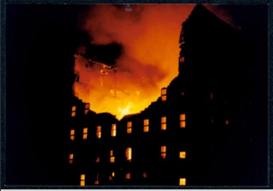
1991 Washburn A Mill Fire, Courtesy of MN Historical Society
As production shifted to other parts of the country, mills began to close and in 1965 all of the remaining mills in downtown Minneapolis were as well. The building sat empty, and in February 1991, fire broke out in the abandoned building nearly destroying it a second time. Since then efforts have been made to safeguard what remains, and excavate some of the ruins of the old original mill.

We had wanted to see it for quite some time and because much of it is outside, we waited until summer to go. In retrospect I have to say that was good only in terms of ease of walking around, however while the museum is good and has a ton of information, the ruins were rather disappointing. Take a look at the photos below; you’ll see what I mean.

From Luvtoexplore Blog
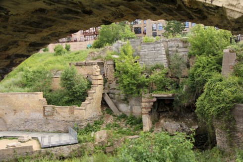
©2017 Beth Younker
The photo on the left is one I found from another blogger on a general Google search (I’ve provided a link to her blog so she gets credit!) taken 10/26/2010, and below is one I took 6/20/2017. You can see how much overgrowth of weeds has been allowed to happen at the site. It’s been virtually taken over by the weeds, trees, and foliage, to the point that there was so much of the ruins that I didn’t even realize existed until I found the other photograph online! For example there is some sort of large round object about halfway up and toward the right side in the left photo, and if I blow up mine and know where to look I can just barely find it.The three windows are nearly obscured, and just off the end of the walkway is a large slab of something. In her photo it’s clearly a piece of structure but in mine it’s almost not noticed. So our visit was interesting, but rather underwhelming, primarily because you just couldn’t see much at all. In addition, I’ve been trying to find information online that has diagrams showing me what it was I was seeing. Don’t get me wrong, there is some information on the small information stations located along the parkway in the area.  But the information isn’t as clear or informative as it could be. One example is where a sign stated that “the tailraces are visible” and it had a picture of tailraces that may have looked a little like this to the right:
Now honestly, does anyone know what a tailrace is? I sure didn’t! And I sure couldn’t figure it out just by looking at the picture. Was it the part sticking out? Was it the part going in? Was it the path over the whole thing? Well, here’s your vocabulary word for today. The tailrace is the place where the water comes out from the flume from the mill, those little small canal-like areas. Here is how those same tailraces appeared yesterday noted by the yellow arrow, from a slightly different perspective.

©2017 Mike Younker
I also mentioned earlier in the blog by that very first photo, that there were remnants of the train trestles still present. You can see them here. They are the bits of rusted iron that are sticking up just to the left of the walking path on the right side of the photo.
Trying to find online maps and diagrams has been fruitless, which is frustrating. I’m not sure why that wouldn’t be available, as it seems it should be relatively easy information to get and provide. Just figuring out what the railroad trestles were was almost impossible until I stumbled on something in someone else’s blog.
I’m not sure if funding for the park has been cut, or if it’s deemed to dangerous to try to get in and weed the ruins or what the issue is. I can say that it was a less than fulfilling experience, and I hope that the Minneapolis Park Board will take a hard look at this. I know in recent years their stance has been to let a lot of areas go back to natural, such as the area around Lake Nokomis, which may work for some areas. Near the ruins there was even a sign indicating that there is work to bring back some of the natural prairie grasses to the hillside. In this case, if in fact they are allowing the mill ruins to revert to their natural state, this certainly means a loss of our rich milling heritage as the ruins are swallowed up by nature and will soon be gone for good.


